The objective of this consultancy is to sort, clean and analyse databases generated by Acción contra el Hambre and partner NGOs in different Central American countries and thus contribute to the knowledge of the potential impact and the determination of the severity of the precipitation deficit in the Central American Dry Corridor, con énfasis en los países que conforman el CA4 (Honduras, El Salvador, Nicaragua y Guatemala mediante Sistemas de Información Geográfica.
También se enmarcan varios objetivos específicos de carácter prioritario, como son:
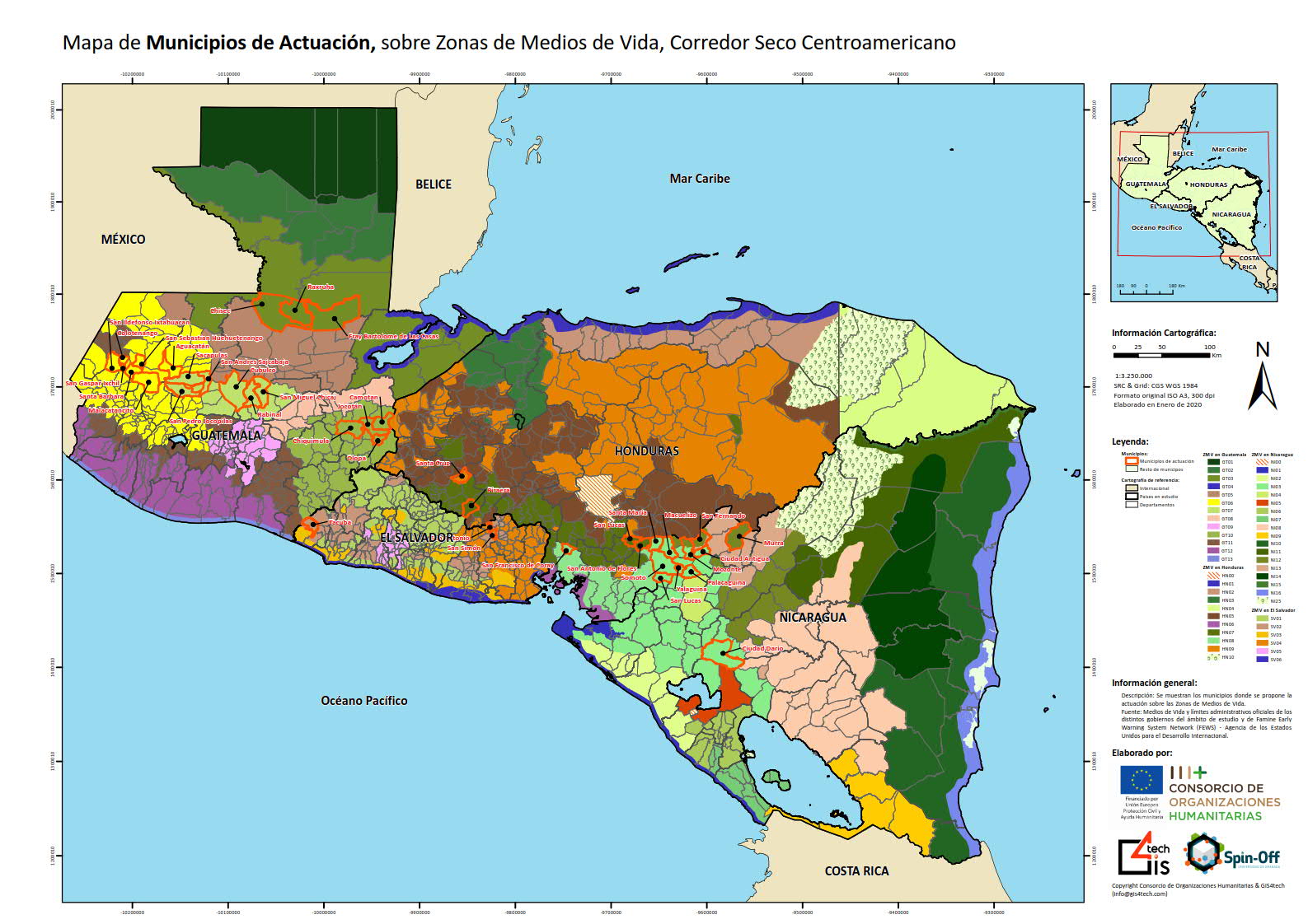
Map of municipalities acting on livelihood zones in the Central American Dry Corridor
These analyses performed through GIS geoprocessing maps will be generated showing the results obtained from the calculation of the SPI parameter for its different periodicities and a series of conclusions will be drawn showing the most affected departments and municipalities in the study area.
Once the standardised precipitation data for the CA4 countries are obtained, the SPI parameter is calculated, using the software SPI Generator. The values used for the representation of the SPI parameter in this Study, its classification and symbology, in line with the recommendations of the World Meteorological Organisation (WMO), are as follows:
SPI | Clasification |
< -2 | Extreme drought |
De -2 | Severe drought |
De -1,5 | Moderate drought |
De -1 | Mild drought |
De 0 | Slight humidity |
De 1 | Moderate humidity |
> 1,5 | Extreme humidity |
Regarding Guatemala, the lack of humidity is particularly affecting the department of Petén and specifically the municipalities of San José, Flores, Melchor de Mencos, San Benito, San Andrés, San Francisco and Sayaxche. Severe drought is also observed in the departments of Alta Verapaz and Quiché. In the latter case, a notorious importance of the study variable is observed in the municipalities of Playa Grande-Ixcan and Uspantan in Quiché, and on the other hand in Coban and Chisec in the department of Alta Verapaz. There are also traces of moderate drought in the departments of Huehuetenango (on its southern border) and Baja Verapaz (in its central and western zone).
With regard to Honduras, in August 2019, precipitation deficits are expected to be widespread, especially throughout the eastern half of the country. Reaching levels of moderate and severe drought are the departments of Olancho, Yoro, Atlántida, and above all Gracias a Dios. Puerto Lempira (belonging to the department of Gracias a Dios) is the municipality where precipitation in August has decreased the most compared to all August of the historical series in the entire country.
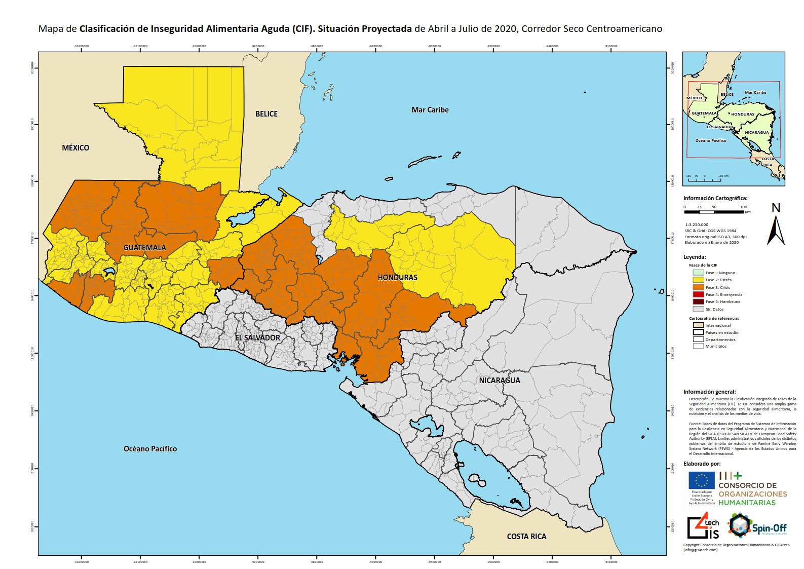
Acute food insecurity (FIC) classification map in the Central American Dry Corridor
In the case of Nicaragua, the lack of humidity and the high rates of drought are more accentuated in comparison with the rest of the territories belonging to the Dry Corridor. Extreme drought rates can be observed along the entire northern frontage (with a marked severity in the northeast). The most affected departments are Jinotega, Matagalpa, RACNNN and RACCS. In addition to the above, the southwest coast is also affected, with Managua, León, Granada, Masaya and Rivas being the most exposed departments. At the municipal level, it is worth noting the negative SPI values obtained in Waspan, Puerto Cabezas, Prinzapolka, Rosita, Siuna, El Cua, Tipitapa, Managua and Masaya.
In El Salvador and unlike the rest, there are no relevant areas of drought except in some areas of the departments of La Libertad and in more localised zones of the departments of Usulatán, San Miguel and San Vicente.
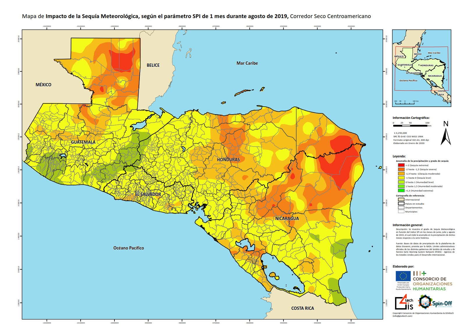
Map of the impact of meteorological drought, according to the 1-month SPI parameter in the Central American Dry Corridor.
Correo electrónico: info@gis4tech.com
