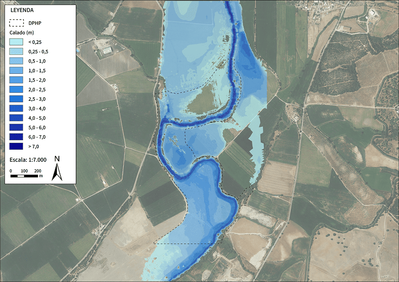
For this study, framed within the Service for the Preparation of Supervision Reports on Hydrological and Hydraulic Studies, three pilot sections of the Guadalete river have been used as it passes through the towns of La Barca de la Florida and El Torno, which were already studied in a hydrological-hydraulic study of the entire Guadalete river basin, carried out in 2007. Our work consisted of a review of the aforementioned hydrological study and its comparison with the results obtained by applying the new NSCFZ methodology for the estimation of the PHD of a riverbed based on its geomorphological analysis, consisting of the photo-interpretation of current and historical orthophotos of the riverbed, as well as LiDAR point clouds with the aim of delimiting the areas flooded ordinarily over the years and thus being able to establish a PPHD (Probable Public Hydraulic Domain) that encompasses current and historical floods.
In the field visit carried out to corroborate the photo-interpretation, evidence of the PPHD delimited in the office was sought, and a GPS was used to georeference the points that had evidence of forming part of the boundary of the PPHD and to be able to correct possible errors in the PHD photo-interpreted in the office. The Total Station was also used to measure the topography of 10 sections of the riverbed in order to correct the DEM subsequently introduced into IBER in the final hydraulic simulation. This has resulted in a definitive delimitation of the PPHD, which will be compared with the methodology traditionally used.
Correo electrónico: info@gis4tech.com
